A student's guide to jobs in GIS and cartography
April 4, 2020
When I was studying cartography at university, I really liked web mapping and map design but I wasn’t sure who would hire me with these skills. Back then, I didn’t even know that the job I have today existed! I’ve been working in the field for about 6 years now and have come across many job types. With this blog post I’d like to give an overview of the possible jobs in GIS and cartography and I hope it will be useful for students and graduates.
When considering a job in GIS, depending on your skills and what you enjoy most, there are three different areas you could work in:
We can split up the types of jobs three ways: — you use GIS and mapping software yourself — you advise users on possible solutions — you develop the software.
Let’s look into them one at a time — each graphic below shows the main tasks needed in this field.
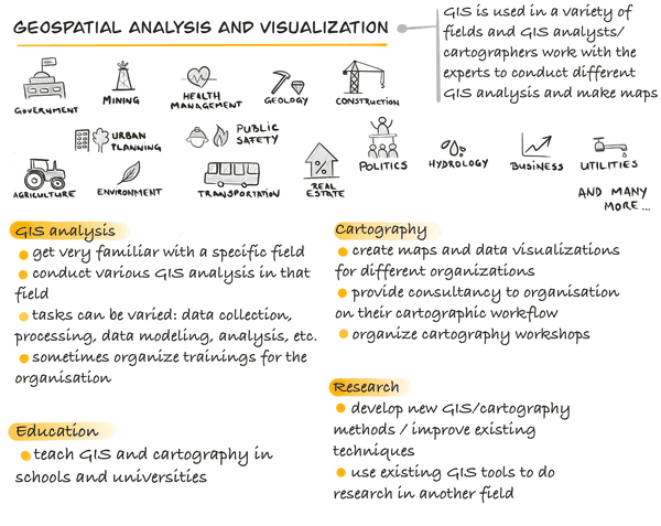
Working as a geospatial expert
This can be very exciting and varied as you can apply your knowledge in various fields. In the graphic below I depicted just a few fields that make heavy use of GIS, but there are many more!
As a geospatial expert for an organization, you’ll get to know their field of work extremely well and you’ll apply your GIS knowledge to that field. Besides database and GIS analysis, some scripting skills will come handy, as many times you’ll be more than happy to automate repetitive tasks. If you think that this is something for you, I’d advise you to learn Python. It is the most common language for data processing, analysis and automation today.
If you’re more inclined towards cartography and data visualization, there’s always the option to create maps for different organizations/companies. Some examples could be companies specialized in tourist maps, news papers, geographic magazines, books, etc. The tools here vary a lot. You can make maps in a GIS software, a vector graphics program (or a combination of both), using a web application (for example ArcGIS Online or Mapbox Studio) or you could code the maps yourself. The latter would involve knowing a scripting language like JavaScript. If you’re more into painting, you can even paint the maps if you work for Bellerby and Co Globemakers!
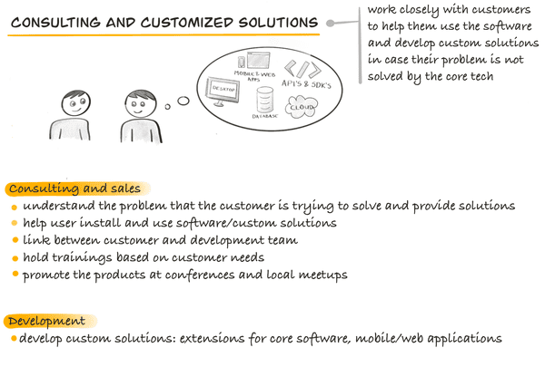
Working as a consultant in GIS and cartography
Working in consulting is awesome if you like to work very closly with customers. The customers come from a variety of fields and you’ll end up learning a lot about their use cases and the problems they are trying to solve. Your role is to come up with good solutions and help them implement those solutions. Sometimes the core technology doesn’t cover the customer’s needs and then some customized solutions need to be implemented. These customized solutions can vary from extensions to existing software or full-blown applications around the customer’s workflow. For example, a company might have its data stored in a custom format that common software doesn’t read. A custom solution would be an importer/exporter from that format to the commonly used ones.
Another side of a consulting job is that you are a vital link between the customer and the development team and you act as a translator between the two. Strong communication skills are therefore essential. Part of your tasks would also be gathering customer requirements and presenting these to the development team. You should also be able to tell both parties what is and is not possible or acceptable.
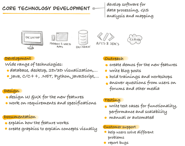
Working in core technology development
Core technology development refers to development of geospatial software. Software in our field comes in all shapes and flavors, from desktop applications to mobile and web apps, databases, server and cloud solutions or API’s and SDK’s for developers. The graphic below shows the main tasks needed in this field. Depending on its size, a company can hire people for some or all the tasks described in the graphic (for example a small company might not have an outreach department).
A job can be a combination of these tasks. For example, I am a Product Engineer for ArcGIS API for JavaScript and help to gather requirements for new features, write documentation, test new features, create demos and write blog posts.
A common misconception back in my student days was that you can only work in software development if you’re a programmer. However, it’s very important to have people involved in development that have a passion and background matching the real world challenges that software is trying to solve. They work together with developers and create great and useful products for end users.
Customer support is a great starting point for graduates, you can learn a lot since you get confronted with all sort of problems that customers are trying to solve. You’ll also improve your communication and analytical skills while already doing important work.
If you think that a job in software development would be something for you, then try to figure out what technology you like to work with and work on several projects using that technology. Think about a feature in the software you’re using — what problem is it trying to solve? Can you think of ways to improve it? Would you like to work on improving, testing and writing documentation to let people know how to use it? In that case, a job in software development might be something for you!
Finally, here are a few more tips and tricks for getting your first job in the geospatial field:
- Build yourself a portfolio: whether it’s a GIS analysis you made for a university project/during a summer internship, a web map or a neat tool you created to improve your workflow, a portfolio shows the employer what you can do.
- Put yourself out there: go to conferences, join local meetups (or organize them!), participate in GIS student competitions, contribute to an open source project, share your work on social media, etc.
- Make a list of companies you’d like to work with and in case they don’t have an open position, apply spontaneously! Explain in a motivation letter what you want to do and what you’ve learned so far. Some companies will create a position if they meet a talented and motivated student who can contribute to their business.
- Let’s be realistic, you’ve got to be very lucky to find your dream job right after graduation. In larger companies you often start with a certain job and then evolve into a different role over time. You might also change your mind and discover other interests in the geospatial field. So think about it as a journey and make the best out of every experience :)
I hope this blog post gave you some ideas on what your future job might look like. If you have any questions, feel free to post them in the comments below or just write to me on Twitter.
Many thanks to great review feedback from Veronika Landers, Mark Wigley and Chris Andrews. And thanks to Diana von Ballmoos for improving the English part of my blog post!


